After a high of 40 degrees and snow showers on Monday, we were happy to see a high of 72 degrees forecast for today. Neither of us could decide which direction to ride, so I suggested that we go find the current Indiana Photo Tag on the advrider.com forum. Essentially, someone posts a picture of their bike in front of a landmark, or some sort of marker, and then someone has to find it, take a picture of their bike with it, and then find a new spot to take a picture of and post it for the next person to find.
The current photo was of the Tank Spring Trail Head in the Martin State Forest, which is about an hour from our house. It was 55 degrees when we left the house, and by the time we got to the park it was 75. The directions I had found online to find the trailhead had said to go straight out of the entrance to the park, across hwy 50, and then follow the signs. We had ridden in this area before, and I didn’t remember seeing a trailhead or any signs for one, but we followed the directions anyways.
After going a ways without seeing any signs, we decided we must have missed it, or perhaps we had misunderstood the direction and it was actually inside the park entrance. We decided to explore a little further in the direction we were going first before doubling back. It ended up being a good decision since we found some really nice gravel roads with some elevation changes and nice scenery. We ended up stopping on one of the gravel roads so I could shed my thin hoodie I had on under my jacket, and Dwayne could shed his thermal shirt. We needed them when we left the house, but definitely not while riding off-pavement in 75 degrees. I checked the map to see where we were and found that if we kept going we would end up back where we started and we could look for the trailhead marker again.
Before we made it back, we found a couple of neat bridges. One was just a small Pratt pony truss bridge built in 1921 (like I said in a previous post, I’m a bridge geek), and the other was this bigger Pratt through truss bridge that was built in 1890.

Once we got back to Hwy 50, we crossed over it into the park, and made a loop through there. After not seeing any signs about the Tank Spring Trail, we decided to go back across 50 and take one more look for signs. At the stop sign where we had previously turned right, Dwayne suggested we turn left down a gravel road instead. Just as I went to make the turn, I saw a tiny little sign, perhaps 4 inches by 12 inches or so that said, “Tank Spring Trail” with an arrow pointing to the left. I laughed and told Dwayne that he was right and to keep going.
As we were going down the road we saw a road to the right named Tank Spring Road, but there was no sign for the trail. Dwayne suggested we go a little further just to make sure since there was no sign for the trail, but the road just looped back up to 50, so we had to turn around and go back. Finally, less than a mile down Tank Spring Road, we found the trailhead and I got my picture for the photo tag thread.

From there we went on down the gravel road, and I looped us back around to the area we had been exploring earlier so we could cut over to another road that we had ridden in the past to take a different route back home. Instead of taking the exact route we’d taken before, which was all paved, I took us on a short gravel detour so we could see more new scenery before heading back.
By the time we made it to Orleans, I was starting to get hungry for lunch, and definitely needed to relieve myself of some of the coffee I’d chugged down before we’d left this morning. We stopped at a gas station and I ran in to use the facilities while Dwayne looked for food. Orleans is a small town, and it looked like the only food was gas station food, so we decided to scoot down Hwy 337 to Livonia where I knew there was a little mom and pop ice cream place that also served food named Little Twirl.
That was really the only part of today’s ride that I personally didn’t enjoy too much. The wind had picked up considerably and was blowing in just the right direction that it felt like it was trying to rip my helmet off from the right side. At one point I even put my left hand up to hold my head because it was causing pain in my neck. It was kind of odd because I really didn’t notice the wind at all at any other point in the day. That is a very straight road, surrounded mostly by open fields, though, so I’m sure that didn’t help matters any.
Once we got to Little Twirl, we split a double cheeseburger and fries, which were surprisingly good. It was a nice little break after fighting the wind, and I felt ready to ride again afterwards. While we were eating we discussed where we should go to get a photo for the new tag to post, and we decided to go to one of two abandoned bridges that were about 30 minutes back to the North of where we were. To get there, we could take back roads though, so we didn’t have to go back up 337 more than just half a mile.
We had been to both bridges before, but one of the two we had only been on one side of it, so I suggested that we come in from the other side to check that out, since you really couldn’t see it from the side we had been to before because they’ve mounded up dirt and stuff to block it off. What I hadn’t considered was the fact that there is still quite a bit of flooding going on around here. So we made it about halfway down the road to the bridge, when the road disappeared into flood water.

We realized with how flooded this side of the bridge was, the other side would probably be even more flooded as it is even lower land, so we didn’t even attempt to get to it. We decided to go to the other bridge instead. On one side of it, you have to ride pretty much through a field to get to it, which we did after we first bought the Tigers, and we did it on street tires, which was a bit sketchy, but still fun. We knew that wouldn’t be an option today though, since it would definitely be flooded, so we went to the other side of the bridge which is on high ground.

Once we got there I was once again reminded how ignorant some people can be, as it was covered in graffiti, including the concrete pillars that block access to the bridge which had something derogatory enough written on them that I had to position my bike in the picture just right so that I could block it out. I really can’t describe to you the level of fury that it makes me feel when I see stuff like that. Why on earth would anyone feel the desire to deface property that isn’t theirs, especially something historical?
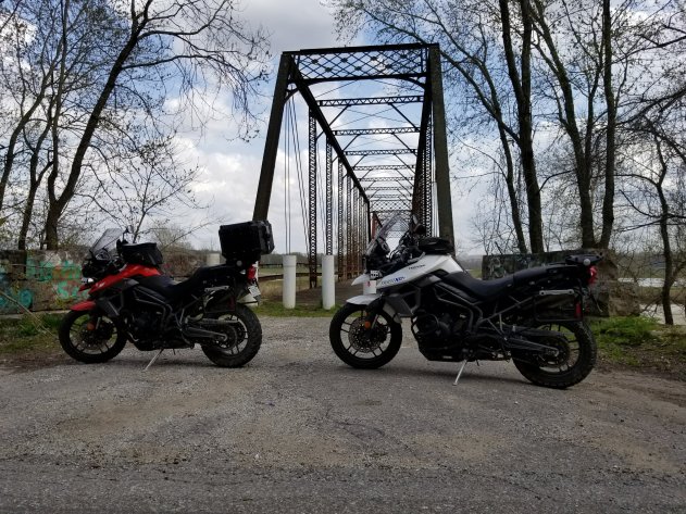
I really wasn’t happy with our choice to use this bridge as my photo tag submission after seeing all of the graffiti on it, plus I’m fairly sure that particular spot may have already been submitted in the past, but I was at a loss for a better spot, and the skies were starting to look like it may storm soon, so we decided to head back towards the house.
As we did, Dwayne led us down some back roads, and actually went a bit further out of route than he had intended, but it actually worked out in our favor. As we were riding along, we saw a sign for one of the Knobstone Trail trailheads, so we decided to double back and use it for our submission instead. As we got to the entrance, we saw a sign for “Spurgeon Hollow Lake” and noticed that the gravel road disappeared into the woods. I wondered out loud how far back in the woods the road went, and Dwayne suggested that we find out. We were rewarded with a tiny little creek crossing, followed by a decent sized little lake with a “Spurgeon Hollow Lake” sign in front of it. I decided that was an even better spot for a photo tag, so we ended up with this instead.

Finally satisfied with my offering, we wound our way back to the house, having only gotten lightly sprinkled on, although the sky looked like it could pour at any moment. I was kind of hoping it would pour on us just so I could test out the waterproofing on my new REV’IT! Horizon 2 suit, but my Heidenau K60 tires aren’t exactly confidence inspiring in wet conditions, so it’s probably just as well that it didn’t.
